
A November surprise?
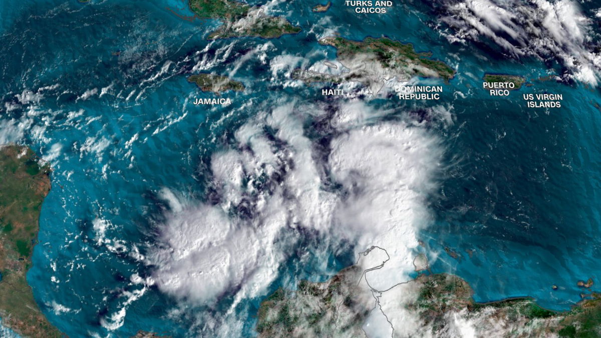
As Americans focus their attention on Tuesday’s election, weather experts are keeping a close eye on a low-pressure system in the western Caribbean that figures to impact the U.S. later this week, though to what extent remains uncertain.
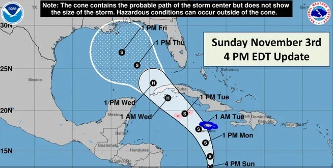
The system, now known as potential tropical cyclone 18, prompted the governments of the Cayman Islands and Jamaica to issue a hurricane watch and tropical storm warning, respectively, the National Hurricane Center said Sunday. Cuba is also expected to be impacted.
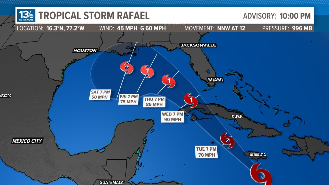
AccuWeather senior meteorologist Dan Pydynowski said 18 may strengthen into a tropical storm in the next day, earning the name Rafael, and could gain hurricane status if it drifts west of Jamaica instead of striking it flush in the coming days.
Regardless, he expects Rafael to eventually be felt somewhere along the central and eastern Gulf Coast, and he urged residents of those areas to be on alert.
“Even if it’s encountering cooler water and wind shear and starting to lose intensity as it comes northward, you’re still going to be talking about a significant wind and rain event,” Pydynowski told USA TODAY. “There are still going to be impacts even if it’s a tropical storm.”
The National Hurricane Center said in its 10 p.m. ET advisory on Sunday that the system is expected to bring heavy rain across portions of the western Caribbean, including Jamaica and the southern and western portions of Cuba through mid-week. Flooding and mudslides are also possible in parts of Jamaica and Cuba.
Heavy rainfall could then spread northward into Florida and other areas of the southeast U.S., according to the hurricane center. Forecasters advised residents in Cuba and the Florida Keys to monitor the system into the week.

A highly damaging hurricane season
Those are worrisome words in a busy hurricane season that has brought enormous devastation from the likes of Beryl, Helene and Milton, among other destructive storms. The U.S. has been hit by five hurricanes this season, killing at least 300 people and causing around $130 billion in economic losses.
Only four hurricanes on record have made landfall in the U.S. mainland on the penultimate month of the calendar, but the most recent one – Nicole – hit Florida a mere two years ago. The season runs through Nov. 30.
Much remains unknown about the current system, its track and chances for intensifying later in the week. The NHC said an Air Force Hurricane Hunter plane was gathering more information Sunday.
But Pydynowski pointed out conditions for strengthening are favorable in the Caribbean, including low wind shear and slightly above-average temperatures in the mid-80s.
The big question for the U.S. is what happens after the storm moves north of western Cuba and into the Gulf of Mexico, possibly by Wednesday. It could initially intensify before encountering harsh wind shear and somewhat cooler water as it gets closer to American soil, which should weaken it.

“It’s tough to get all the way to hurricane status to hit the central Gulf Coast this time of year, but certainly it can happen,’’ Pydynowski said. “The water is still in the upper 70s, it’s still warm. Especially if the storm is moving quickly, so it doesn’t spend a lot of time over cooler water.’’
For residents of the southeastern coast, especially in hurricane-battered Florida, it would be much preferable if the storm slows down and cooler water prevails.
Signs of trouble still lurking
The hurricane center said a trough of low pressure near the southern Bahamas has produced showers and thunderstorms but will likely be absorbed by the evolving storm that may become Rafael by late Monday.
But there are still signs of further activity in the northern Caribbean and perhaps the far southwestern Atlantic around the Bahamas, Pydynowski said, underscoring that the season doesn’t end for nearly another four weeks.


Tropical Storm Rafael heads toward hurricane strength before Cuba landfall Wednesday, forecasters say
A tropical forecast and monitoring our local weather too
More severe weather expected Monday as Oklahoma surveys damage from tornado-spawning storms that injured 11

More severe weather is expected in the Southern Plains Monday as residents in Oklahoma survey the destruction from tornado-spawning storms that injured at least 11 people and leveled homes over the weekend.
Severe thunderstorms will continue to sweep through the Southern Plains overnight and ramp up again Monday for northern Texas, western Arkansas, southwestern Missouri, and most of Oklahoma. Areas including Oklahoma City could see more twisters.
While the ongoing storms will eventually weaken Monday morning, severe weather conditions are expected to ramp up in parts of the region during the day and could last into the evening –– threatening many of the same areas that have been battered by tornadoes and flooding over the weekend.
“Scattered severe thunderstorms, associated with tornadoes, large hail, and wind damage, are likely on Monday and Monday night from the Southern Plains north northeastward into the Ozarks and mid Mississippi Valley,” the Storm Prediction Center (SPC) warned. “A few of the tornadoes could be strong.”
A lower warning of severe storms will spread from central and eastern Texas to western Illinois – including the cities of Dallas, Houston, Austin, and St. Louis – threatening damaging wind gusts, large hail and tornadoes, according to the SPC.
Heavy downpours could also inundate streets. More than 7 million people are under flood watches across northern Texas, most of Oklahoma, southeastern Kansas, northwestern Arkansas and southern Missouri.
At least five tornadoes, combined with intense flooding from heavy rainfall, ripped through parts of Oklahoma late Saturday into Sunday –– destroying homes and other structures.
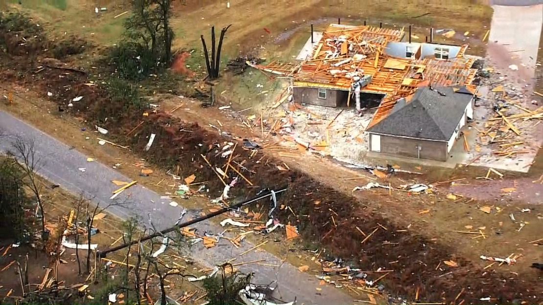
Video of the damage from CNN affiliate KOCO shows cars overturned and whole houses shredded. The storms toppled telephone poles and snapped trees in half. Debris is scattered around impacted areas, including large pieces of wood and metal from buildings that were ripped apart.
Nearly 40 structures were destroyed in the Oklahoma City area, the Oklahoma City Fire Department said in a Facebook post. Another 43 structures sustained major damage, while 54 had minor damage.
At least 11 people were taken to hospital with non-life-threatening injuries, OCFD said Sunday night, adding that several others sustained minor injuries but declined to seek medical help.
Residents hide as storms damage homes
Katie Anderson, a resident in southeast Oklahoma City, told CNN affiliate KOKH that she woke up on Sunday to the sound of a severe storm alert from her phone –– what she initially thought was her alarm for church. She then quickly realized that there was debris hitting her house. Heavy rainfall from the storm had collapsed her roof in multiple places.
“Every single thing is replaceable, but people aren’t,” Anderson said. “For us to walk away with no injuries and absolutely no issues at all, that means way more to me than whether or not I have a couch of a roof.”
“It was the loudest that I’ve ever heard in my life,” Thomas Shaver, another Oklahoma City resident, told KOKH, describing a big boom that sounded like a train Sunday morning.
In the midst of the intense storm, Shaver told KOKH that he pulled his daughter and wife into one of the hallways in their house and started praying. He said that the bedrooms in his house are now gone –– along with part of the roof.
“A lot of damage to the cars and things but some things survived and we’re still able to get around so very grateful for that,” he told the outlet.
Oklahoma Gov. Kevin Stitt has issued an emergency declaration for six counties. Officials were working to ensure that polling stations across the state would have power ahead of the presidential election Tuesday, Stitt said in a news conference Sunday.
“We’ll advise the public if there’s any issue there with the polling stations and reroute people if need to,” the governor said. More than 16,000 electricity customers in Oklahoma and Texas were still without power Sunday night, according to PowerOutage.US.
Stitt warned that potential life-threatening conditions will move across the state. “Utility restoration is underway where conditions permit and the state is working closely with local partners to make sure Oklahomans have what they need,” he said in a post on X.
The five tornadoes the National Weather Service has confirmed so far include two believed to have been powerful EF-3 twisters, one in Harrah and another near Sooner Road in Cleveland and Oklahoma counties. Tornado strength is measured using the Enhanced Fujita Scale or EF Scale, which rates tornadoes from EF-0 to EF-5 based on estimated wind speeds and related damage.
Most of the tornadoes hit during the dark overnight hours, with residents waking up to splintered buildings and trails of debris.
Nighttime tornadoes are more than twice as deadly as daytime ones, research shows, since nocturnal tornadoes are difficult to spot in the darkness and those sleeping may not be aware that danger is near.
At least 11 injured after tornado-spawning thunderstorms left a trail of destruction across parts of Oklahoma
Tornadoes and flooding spawned by severe thunderstorms tore through parts of Oklahoma overnight, leaving at least 11 people injured and shredding homes and other properties.
Residents in Oklahoma and Texas are bracing for more severe weather Sunday, including possible tornadoes, flash floods, hail and strong winds.
The National Weather Service issued warnings for parts of both states Sunday afternoon. The severe weather is expected to move from west to east Sunday, the weather service said.
Eleven people were taken to the hospital with non-life-threatening injuries after the storms overnight, said Scott Douglas, public information officer with the Oklahoma City Fire Department. Several others suffered minor injuries but declined to seek medical treatment.
Several structures were damaged in the area, along with power lines, trees, gas lines, traffic signals, and traffic signs, said Valerie Littlejohn, public information officer with the Oklahoma City Police Department.
As of 1:30 p.m. CST Sunday, 39 structures had been destroyed, according to Oklahoma City officials. Additionally, 43 structures sustained major damage, while 54 had minor damage.
More than 20,000 customers in Oklahoma and Texas were without power Sunday afternoon, according to PowerOutage.us. In Oklahoma City alone, 5,000 residents were without power as of Sunday afternoon, according to the city.
Oklahoma Gov. Kevin Stitt issued an emergency declaration for six counties, he announced at a news conference Sunday.
Officials are working to ensure polling stations across the state have power ahead of the presidential election Tuesday, Stitt said. “We’ll advise the public if there’s any issue there with the polling stations and reroute people if need to,” the governor said.
Local fire crews as well as National Weather Service teams are surveying the damage Sunday, including in the town of Valley Brook, Harrah and Newcastle where the storms caused severe destruction.
Video of the damage from CNN affiliate KOCO shows cars overturned and whole houses shredded. The storms toppled telephone poles and snapped trees in half. Debris is scattered around impacted areas, including large pieces of wood and metal from buildings that were ripped apart.
Around 1:20 a.m., the weather service warned a severe thunderstorm with a tornado was moving through eastern Oklahoma City toward Midwest City and Tinker Air Force Base. A tornado warning was issued for over 300,000 people in Moore, Midwest City and Del City.
“I was awake, and I heard it pick up very quickly,” said Justin Cue, describing the moment a possible tornado struck his father’s home overnight, leaving him with minor injuries from flying glass and debris.
“Debris started hitting the house, and after a few seconds my window blew out and then all you could hear was the roar of the wind and the ripping wood and glass shattering,” Cue told CNN.
Cue’s father, who moved to Oklahoma City from Kansas about two years ago, was also injured when the roof collapsed on him. “He was unconscious for a brief time and we weren’t sure he was OK,” Cue said.
When the pair was able to get out of the home around 1:30 a.m., Cue said neighbors were yelling and helping get people out of the rubble until first responders arrived.
Tornadoes were reported just east of Oklahoma City, and tornado and thunderstorm warnings were in place through early morning in the Oklahoma City area, the weather service said.
“Folks, don’t let your guard down too much – we’re already starting to see the atmosphere begin to recover ahead of yet another round of thunderstorms, heavy rainfall, flooding, and potential severe weather today,” the weather service said in a post on X.
The National Weather Service issued a tornado watch for parts of Oklahoma and a few counties in northern Texas until 8 p.m. CST Sunday. The watch includes Oklahoma City and surrounding cities southeast, affecting more than two million people.
Supercell thunderstorms are firing off the same front that caused damage overnight. These new storms are capable of a few tornadoes, ping pong ball-sized hail, and 75 mph damaging winds.
“Clusters of intense thunderstorms over southwest Oklahoma and northwest Texas will track rapidly northeastward this afternoon across the watch area. Strong low-level shear will support a risk of tornadoes and damaging wind gusts with these storms,” according to the weather service’s Storm Prediction Center.

Police are asking people to avoid some roads in the area due to the damage.
First responders rescued two people trapped inside an overturned mobile home after the storms hit, according to the Oklahoma City Fire Department. They also responded to several vehicles that were flooded due to heavy rainfall, according to Douglas.
The University of Oklahoma told students and staff on its Norman campus to “Seek shelter NOW inside the building you are in. Move to lowest floor/interior.”
Nighttime tornadoes are more than twice as deadly as daytime ones, research shows. Nocturnal tornadoes are difficult to spot in the darkness and those sleeping may not be aware that danger is near.

There’s heightened concern over the tornado threat this week given how prolific a year it has been for twisters in the US. The number of tornadoes reported so far this year is the second-most on record, trailing only 2011’s 2,156.
Violent thunderstorms are most common in spring and summer, but a second surge of dangerous storms and tornadoes happens during fall and winter as cold air from the north often collides with warmer, moist air streaming out of the Gulf of Mexico.


